Springfield, APSU partnership maps future through GIS
By KATE COIL
TT&C Assistant Editor
The city of Springfield is partnering with Austin Peay State University’s Geographic Information System (GIS) Center on a project that is helping the city make data-driven decisions and training the GIS workforce of the future.

Established in the 1998-1999 school year as a partnership between the university, city of Clarksville, and Montgomery County, the university has since taken over the center, which still provides GIS services to both Clarksville and the county.
GIS is a computer system that takes digital geographic data points and stores, manages, analyzes, edits, and visualizes that data. APSU’s GIS Center allows students to get hands-on experience in the field, often partnering with local governments and organizations to complete projects often too big to do in-house but too expensive to contract out.
Doug Catellier, project manager with the APSU GIS Center, students from APSU have worked through the center to gain experience, while providing cost-effective services to area municipalities.
“In today’s world, one of the biggest benefits to a local government or municipality in working with us is the cost,” he said. “Everybody is outsourcing everything because it’s relatively less expensive. When you have a center like ours that has the experience and the workforce we have, we don’t have to charge as much. We’ve done work for smaller towns like Kingston Springs and Pegram where it is more cost effective to reach out to us. We get the project done, we set them up with what they need to set up with, and then at the end of the project, they can maintain that work easier.”
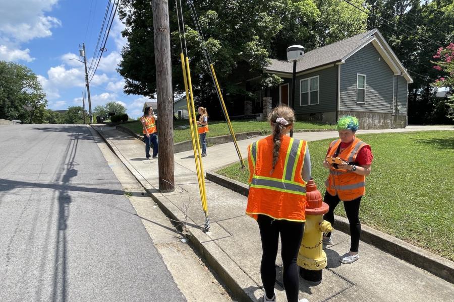
Past projects by the center have included floodplain mapping the area in and around Waverly during and following the devastating 2022 floods and setting up GIS services for the city of Clarksville. Recently, APSU students and the GIS Center have been working in Springfield to map the city’s extensive water and wastewater infrastructure.
“We went out and tagged all the hydrants and manhole covers last year,” Catellier said. “They were happy with that, and this year, they asked for all their service meters collected. We are in the process now of doing that, and getting it all mapped out for them. We will then turn the data over to the city for them to manage.”

Springfield’s municipal water assets not only serve nearly 20,000 residents within the city limits, but also as far south as the Robertson-Davidson county line and as far north as the Tennessee border with Kentucky.
Caleb Groom, GIS coordinator for the city of Springfield, and Todd Evilcizer, the senior engineering technician for Springfield’s Water and Wastewater Department, have been working alongside the students on the project.
If only the two of them had been working on this project, Evilcizer said collecting all the data on mains, service, meters, valves, lines, and other information could have taken as long as five years. With help from APSU students, the project is now projected to take less than two years to complete.
“It was such a large area of data that needed to be collected, and this speeds things up,” Evilcizer said. “There was a lot of area to cover, and we wanted to do it as quickly as possible. As many customers as we serve, one person in the field trying to gather all that data would invest so much time. It helps to have two other people working with you in the field. What they do when they get back in the office with the data takes care of a lot of it as well.”
Catellier said students are hired and trained by the center on various equipment and how to collect data. They also have the responsibility to interact with the client and make sure the needs of the project are met.
“We get resumes when we are hiring these students and full-time personnel when that need arises,” Catellier said. “In most cases, the classroom projects they are working on use canned data. There are no mistakes in it; everything works fine. Through this, they are handling raw data. They may have to do some troubleshooting to figure out what things are versus what they need to be. There are things they can’t be taught in a classroom.”
Students also learn how municipalities use GIS.
“We work hand-in-hand with a lot of municipalities, so these students get a front row seat to see how these municipalities are using data to make decisions and keep track of infrastructure,” Catellier said. “Now these students can fill in that role because they are already familiar with how different municipalities work.”
Catellier said GIS allows data to be explored in new ways.
“The important thing is not the data but how you view the data,” he said. “If we give you a spreadsheet of data, you might have no idea what you are looking at. When we take that spreadsheet and place it in the proper geographic location so you can visualize, it brings in more perspective. They can see that data in relation to other geospatial data.”
Evilcizer said the data APSU is providing the city with more in-depth information than they previously had available.
“Our previous data on the water and sewer system was all done on AutoCAD,” he said. “We had mapping in place showing lines, hydrants, sizes, and all of that. But with GIS, we can attach attributes to valves like what kind it is, what size it is, and how many turns it takes to close. There is just a lot more detail you can get in one click as opposed to viewing it on a map.”
Groom said the project is allowing Springfield to view its water infrastructure in new ways.
"The fire department has to know where all the hydrants are, so they can easily and quickly access that information,” he said. “If a water main breaks, we know exactly where to dig to find a problem area. It’s also preventative. You get a lot more nuance with your data in GIS.”
One way Springfield has used GIS is to make a development tracker, allowing residents to see where new commercial, residential, and industrial facilities are being built in the rapidly expanding city. Groom said the data is also helping make plans for the future.
“When making a map, you can see where is the best place to put a park, what area has the most foot traffic, and where is the best place to put a traffic light,” Groom said. “There are just so many pieces of data – whether its electric, water, gas, or demographic data – that we can use.”
The GIS Center is also a resource for municipalities to explore what they can do with GIS.
“We started off working with the city of Shelbyville to get their data mapped out to make some decisions,” Catellier said. “After about two years, they realized they had a lot they wanted to do with that data. They then moved forward with creating a GIS technician position, and we helped them hire for that position. That person still works directly with us to help them build out their data.”
More information about APSU’S GIS Center and how to collaborate with them is available on the center’s website.